土壌水分含有量測定


概要
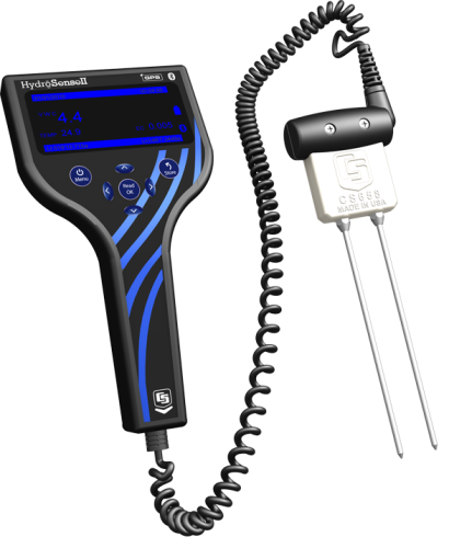
HS2は、新しいHydrosense(ハイドロセンス)II土壌水センサ用のハンドヘルドディスプレイです。CS658またはCS659ポータブル土壌水プローブと組み合わせると、以前のHydrosense土壌水分システムを置き換えられます。新しいハンドヘルドディスプレイとプローブデザインが特徴です。HS2ハンドヘルドは、コンパクトで持ち運びに便利な設計になっており、ボタンレイアウトの修正により片手での操作が可能です。
続きを読む利点と特徴
- コンパクトで軽量
- 現場でリアルタイムな土壌水分含有量値を読み取ります
- 操作が簡単な大型LCDディスプレイ
- 最大1500ポイントのデータストレージ内蔵
- GPS搭載
- PCソフトウェアへのBluetooth接続
- Google Earth、GPX、CSVへのエクスポート
- プローブの再設計により、挿入と取り外しが容易
イメージ


詳細
携行ディスプレイ
土壌水分プローブ
HS2のプローブは、従来のHydrosenseプローブと同じ正確な測定技術を使用していますが、ハウジングは硬い土壌への挿入や抜き取りを容易にするために再設計されています。プローブロッドはフェルールナットでハウジングに固定され、挿入時の安定性を高めています。成形プラスチック製グリップがセンサケーブルとハウジングを接続し、持ちやすい形状に進化しました。
ソフトウェア
-
テーブルビューとグラフビューでデータを表示する
-
ゾーンの位置とサイズの編集
-
デバイスの設定を変更する
-
データをCSVにエクスポートして、サードパーティのソフトウェアと接続
- Google Earth でゾーンと計測値を表示する
仕様
| 測定項目 | 多孔質媒体(土壌など)の体積水分含有量(VWC) |
| 必要なシステム | HS2 はスタンドアロンシステムです。 |
| 土壌適合性 | 短いロッドは硬い土壌に簡単に設置できます。電気伝導率の高い土壌に適しています。 |
| ロッド | 交換可能 |
| センサ | 交換可能なセンサ。12 cm と 20 cm センサを交換できます。 |
ディスプレイ |
|
| ディスプレイ | 128 x 64 ピクセルのグラフィック LCD |
| バックライト | 青と白の LED (明るさ調節可能) |
| GPS 精度 |
|
| Bluetooth 範囲 | 約 10 m (~30 ft) |
| データ保存 | > 1000 レコード (リングメモリ) |
| ゾーン保存 | > 100 レコード |
| 電源 | 6 Vdc、単三電池 4 本 |
| バッテリー寿命 | 6 ~ 12 か月 (一般的な使用において) |
| 寸法 | 200 x 100 x 58 mm (7.9 x 3.9 x 2.3 in.) |
| 重量 | 340 g (12 oz) |
ディスプレイの標準的な消費電力 |
|
| スリープ | 20 µA |
| バックライトオフ | 2 mA |
| バックライト 60% | 18 mA |
| バックライト 100% | 30 mA |
| GPS 有効 | 35 mA |
| Bluetooth 有効 | 30 mA |
プローブオプション |
|
| -注意- | CS659 と CS658 はロッドを共有できません。 |
| 水分含有量の正確度 |
|
| 体積水分含有量の分解能 | < 0.05% |
| 体積水分含有量の範囲 | 0% ~ 50% VWC |
| ケーブルの種類 | スパイラル |
| ケーブルの長さ | 250 cm (98 in.) 伸縮します |
| ロッドの直径 | 5 mm (0.14 in.) |
| ロッドの長さ |
|
| 本体の寸法 | 100 x 92 x 40 mm (3.9 x 3.6 x 1.6 in.) |
| 重量 | 450 g (15.9 oz) |
互換性
システム
センサ
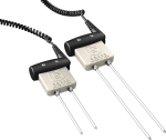
HS2には注文時にCS658またはCS659のいずれかを指定できます。またオプションとして別途センサ部のみを購入することもできます。CS658は20cmのロッド、CS659は12cmのロッドです。
注意:CS658とCS659はロッドを共有できません(12cmのロッドはCS658では使用できず、20cmのロッドはCS659では使用できません)。
動画とチュートリアル
ダウンロード
HydroSoft v.1.0.8 (5.16 MB) 26-07-2012
Current version of the HydroSense II Support Software.
よくある質問
HS2に関するよくある質問の数: 19
すべて展開すべて折りたたむ
-
水分含有量データ ファイルはリング メモリとして構成されており、1,000 を超える値を保持できます。ファイルがいっぱいになると、最も古いデータが上書きされ、保存が続行されます。
一方、ゾーン データ ファイルは、フィル アンド ストップ メモリとして構成されています。ゾーン データ ファイルには、作成されたゾーンのリストが保持されます。新しい場所にデータが保存されるたびに、ゾーンが作成されます。各ゾーン レコードには、中心位置 (緯度と経度)、メートル単位の半径、およびゾーン名が含まれます。ゾーン データ ファイルには 100 を超えるゾーンを保持できますが、ゾーン データ ファイルがいっぱいになると、DISK FULL エラーが表示され、古いゾーンが削除されるまで新しいゾーンを作成できません。ゾーンを削除するには、次の手順に従います。
- HydroSense II サポート ソフトウェアを使用して HS2 に接続します。
- Map Viewに移動します。
- 不要なゾーンを右クリックし、[Remove] を選択します。
-
HS2 は 4 本の 単三電池で動作します。電池はユーザーが交換できます。
-
不足モードを使用する場合、100% RWC を超える値は、水分含有量が湿潤基準を超えていることを示します。詳細については、HS2 取扱説明書の「Operation」セクションの「Water Deficit Data」サブセクションを参照してください。
-
VWC の読み取り値が (---) の場合、土壌の水分含有量が 50% を超えているか、土壌の EC (電気伝導率) が範囲外であることを示します。詳細については、HS2 取扱説明書のセクション 6.3、6.4.4.3、および 6.4.4.4 を参照してください。
-
いいえ。HydroSense と HydroSense II のディスプレイとセンサは互換性がありません。
-
いいえ。HS2 は Bluetooth 通信を使用します。
-
詳細な比較については、HS2 取扱説明書の「Overview」セクションの表 4-1 を参照してください。
-
いいえ。旧モデルの HydroSense にはデータを保存する機能はありませんでした。HS2 は、HydroSense データに使用される既存のデータ ファイルにマージできる CSV ファイルを生成します。ただし、HS2 からの CSV 出力ファイルには、オリジナルの HydroSense では測定されなかった追加のパラメータが含まれます。
-
-
いいえ。これらの製品は販売終了しています。
- CD620 ディスプレイは HS2 に置き換えられました。
- CS620 水分含有量センサは CS658 および CS659 に置き換えられました。
Privacy Policy Update
We've updated our privacy policy. 詳細はこちら
Cookie Consent
Update your cookie preferences. クッキーの設定を更新する


