
Real-time Data Collection, Monitoring, and Alarming


概要
Contrail is an enterprise-level software solution for the real-time data collection and visualization of data used in Flood Early Warning (ALERT/ALERT2), Dam Monitoring and Reservoir Operations, Road Weather (RWIS), Irrigation and Water Accounting, Stormwater Management, and more.
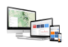
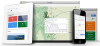
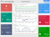
Contrail collects, processes, and validates data in real time from virtually any sensor type and transmission protocol. The software, compatible with Campbell Scientific equipment, provides web-based operational decision support and early warning notifications via pager, email, and text message. It is designed to meet the demands of mission-critical applications, providing up-to-the-minute visualization of current conditions and presenting data in easy-to-understand, high-resolution maps, dashboards, charts, graphs, and tables. Contrail is fully web-based and enables users to view, manage, and analyze real-time and historical data in one place.
Contrail is easily configurable for diverse users, providing data that may have to meet and serve the needs of many different applications—whether for flood early warning, dam safety operations, road-weather condition monitoring, stormwater and water quality, or public information. With Contrail, you can control access to the data set that each user or group of users can see and expose different data sets to different sets of users, so they see what is relevant to them.
Contrail is available from OneRain as licensed software to purchase and operate locally on your organization’s own network, and as a cloud-based hosted and managed application.
利点と特徴
- Flexible deployment with licensed on-premises and cloud-hosted application options, or operation via a combination of both for mission-critical applications
- Seamless integration and automated data collection from many sensor types, communication protocols, and multiple sources
- 24/7 intranet/Internet browser-based desktop and mobile access for an unlimited number of users with role-based privileges, data views, and security settings
- Own Branding and Web Content Management ― Enables administrators to easily manage system data and customize the look and feel with an organization’s colors and logo
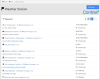
- Advanced Alarm Management with Boolean/Expert Equation toolset, enabling highly customizable, user-defined alarm rules and messaging features that support decision-making criteria and EAP (emergency action plan) procedures and escalation processes
- Groups and Contacts feature for delivery notifications to simplify the creation, management, and communication of automated alarm messages via pager, cell phone, and email
- High-resolution, custom, static maps and pan-and-zoom maps to clearly define sensors and their status; Map Overlays to allow the integration of radar, spatial rainfall, flood inundation, and GIS layers onto custom maps
- Powerful data analysis and integrated reporting tools to help understand what’s going on end-to-end with a system
イメージ

ケーススタディ
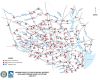
ALERT2 は、洪水警報コミュニティにおける 40 年の伝統を改良した最新の通信プロトコルです。ALERT2 は、正確でタイムリーなデータを確実に提供することで、従来の ALERT 洪水警報システムのパフォーマンスを向上させるように設計されています。2014 年以来、Campbell Scientific は、顧客の特定のニーズを満たすように設計された ALERT2 トランスミッターとカスタマイズされたソリューションのラインを提供してきました。2015 年を通じて、ハリス郡洪水制御地区 (HCFCD) は、Campbell......続きを読む
記事とプレスリリース
Privacy Policy Update
We've updated our privacy policy. 詳細はこちら
Cookie Consent
Update your cookie preferences. クッキーの設定を更新する