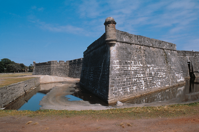
Castillo de San Marcos National Monument, St. Augustine, Florida. Taken in 1995, this view looks across the moat toward the southwest bastion, where several major cracks are visible.
Sensors are installed across a crack in the southwest bastion.
Sensors straddle cracks to directly measure displacement in each of three axes.

The Castillo de San Marcos National Monument, St. Augustine, Florida, is a 17th Century historic, cultural, structural, and civil engineering landmark. The Park Superintendent, Gordie Wilson, together with the Southeast Region of the National Park Service, has commenced a long-range monitoring effort at the fort. The goal is to better understand the causes of movement—and the resulting cracks—that have plagued areas of the fort walls for two hundred years.

The fort’s bastions are earthen-filled, masonry ramparts, constructed on shallow foundations. Two of the four bastions have evidenced cracks since the early 1800s. The fort’s foundations ought to be structurally sound according to an extensive investigation of both the foundations and the soil bearing capacity. An emerging theory postulates that the wall construction is near its structural limit in retaining the earth fill. Rainwater infiltration may increase the internal load on the walls, causing the structure to move. A design team was formed to investigate this theory. Headed by architects Grieves Worrall Wright & O’Hatnick, the team proposed that the park monitor:

  • Existing cracks in three dimensions
  • Tilt of the large segments between the major cracks
  • Change of soil moisture with in the bastion at two levels, one near the surface and one 16 feet deep
  • Weather conditions at the site to assess their impact on geotechnical activity 

Monitoring equipment was assembled from several vendors. Campbell Scientific provided the datalogger, multiplexers, weather stations, and soil moisture probes. The equipment was integrated with crack and tilt sensors manufactured and installed by Geokon (Lebanon, NH). AMJ Equipment (Lakeland, FL) and PSI Engineering (Jacksonville, FL) provided technical and installation assistance. To reduce the installation’s aesthetic impact on the park, cables were concealed in custom conduit with the help of the park’s maintenance staff.

The sensors are measured and the data are stored by the CR10X at 5 a.m. and 5 p.m. On a quarterly basis, the data stored in the CR10X is downloaded via phone modem to computers located in the offices of the engineers and architects for analysis and interpretation. The project is scheduled to collect data for five to ten years.

We're active on social media!
Stay informed with our latest updates by following us on these platforms:

ケーススタディの概要

アプリケーション

Monitoring structural cracks, soil moisture, and weather conditions in support of preserving the Castillo de San Marcos

場所

Castillo de San Marcos National Monument, St. Augustine, Florida, USA

使用製品

CR10X 

寄稿者

David Wright, architect Grieves Worrall Wright & O'Hatnick

参加団体

National Park Service

計測項目

x-y-z movement along cracks, tilt, soil moisture, meteorological conditions

Related Website

Castillo de San Marcos


PDFで見る